SatGen 4 Release Notes
- ►SatGen 4 - v4.2
-
New Features
Added Support For Real-Time Simulation With LabSat 4
The LabSat 4 Realtime output format has been added to support real-time simulations with LabSat 4.
Added Support For Orbital Trajectories
You can now create Orbital Trajectories by using the new feature in Map Mode. When clicking on the Orbital Trajectory routing option, the Orbital Trajectory configuration window will open, where you can configure the trajectory as required.
Added SBAS Signal For Simulations
You can now select satellites from the SBAS constellation to be used in scenarios and simulations in SatGen 4.
Added Recent Files List in the File Menu
You can now find a list of the most recent files saved or opened in SatGen 4.
Optimizations
- Improvements to road routing logic.
- Support for Novatel OEM7 logging IONUTC messages during SatGen simulations.
- Support for Novatel OEM7 logging ALMANAC messages during SatGen simulations.
- Improvements to stability when generating from a previously saved .sgen file.
- Improvements to routing display.
Bug Fixes
- Fixed bug where parts of a trajectory changed to a straight line after saving.
- Fixed bug where altitude was not being applied correctly in script mode.
- Fixed bug with saving trajectories as KML, CSV & NMEA.
- Fixed bug where GPS L1+L2 signal simulation was unstable when replaying to Novatel receivers.
- Fixed bug where satellite controls did not take effect during simulation.
- ►SatGen 4 - v4.1
-
New Features
LabSat 4 Output Format
The LabSat 4 output format has been added to support the new LabSat 4 product:

LabSat 4 features a 12-bit I&Q quantisation and a flexible 10 to 60 MHz bandwidth for optimised channel setups. It has a wider dynamic range, more resolution in the signal, improved data transfer and larger storage capacity than its predecessor.
For more information about LabSat 4, please visit the website or enquire here.
Scenario Timeline
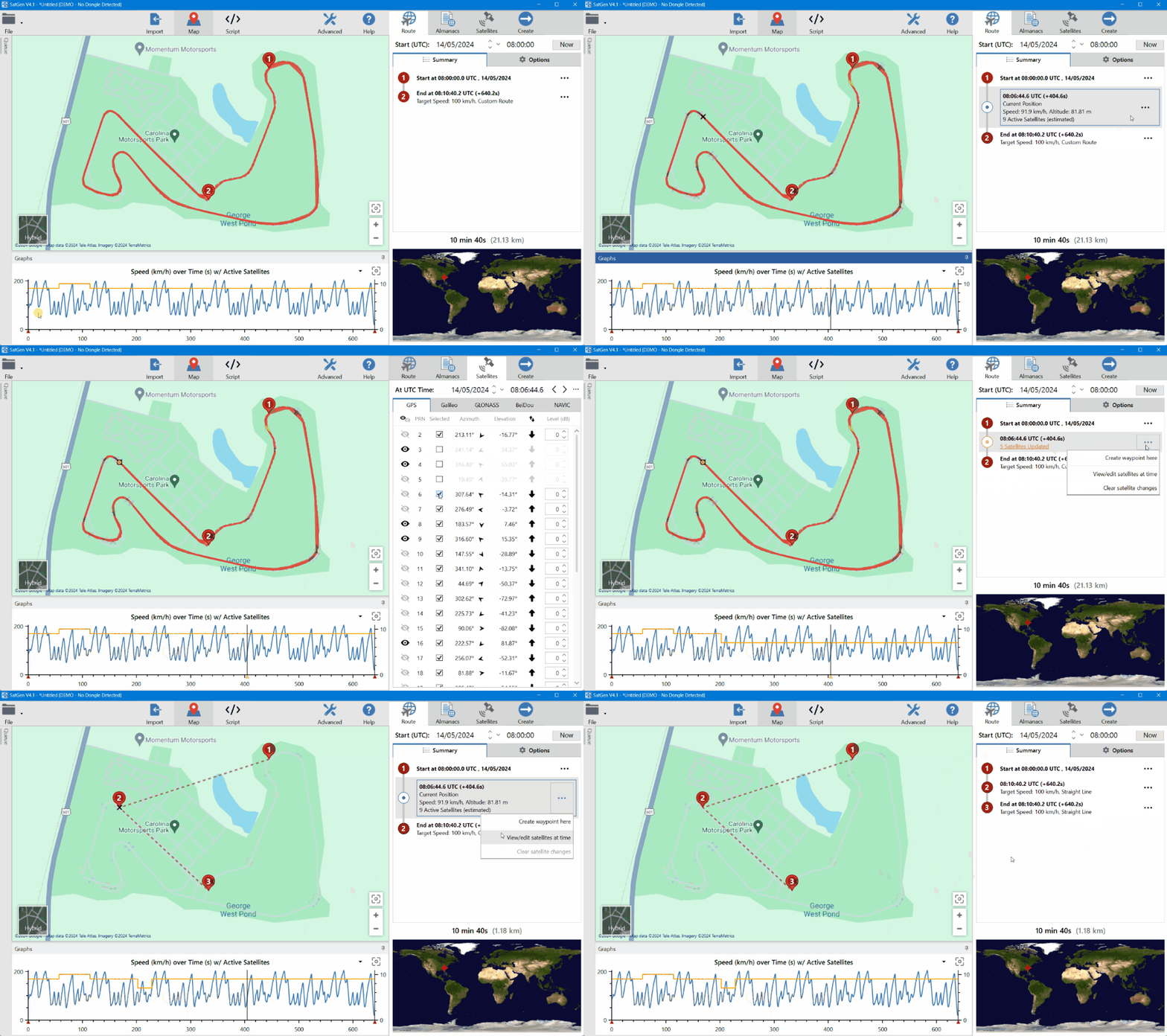
SatGen 4 now includes the ability to view and change satellite levels and the satellites being simulated on the scenario ‘timeline’.
The graph can now show active satellites that will be simulated based on location, time and selected signals:
The satellites are represented as a yellow line on the graph and the y-axis for the satellites will appear on the right-hand side of the graphs with active satellites.
Triangle markers on the chart's x-axis indicate waypoints and user-entered satellite changes on the timeline.
Satellites tab relative to time/position
The Satellites tab now shows the satellite information for a given time or waypoint. In the previous version, data was shown for the start of the simulation only. When you click on the graph to set the cursor position, the Satellites tab will display the satellite data for that time.
You can now amend satellite levels and select/deselect satellites for simulation.
You can make amendments either ‘at waypoint’ or ‘at UTC Time’.
You can use the < > arrows to move between waypoints or times where satellites have changed.
Route Summary
The route summary now lists entries when a satellite change has been specified by the user:

Script Mode
You can also set satellite selection and level in a scripted scenario by using the Satellite script function.
Multiple LabSat Real-Time units
If you connect multiple LabSat Real-Time units to the same PC, you can now select the target LabSat Real-Time unit. You can open multiple instances of SatGen, each streaming to a different LabSat Real-Time unit.
Disable Ionospheric and Tropospheric Delays
You can now disable Ionospheric and Tropospheric delays entirely in the Advanced settings.
Update to .ini Files
.ini files for LabSat 3 Wideband and LabSat 4 now contain a list of all the signals used in the simulation.
Additional Graphs
Additional graphs are now available for selection:
Improvements
- Geostationary BeiDou satellites are now simulated on all devices including LabSat 2 and LabSat 3 units.
- Artificial noise (software attenuation) quality improved.
- Accuracy of the Klobuchar ionospheric model significantly increased. It now follows the principles from the original paper by John Klobuchar published in 1987.
- Performance when displaying the chart for long scenarios has been improved significantly.
Bug Fixes
- Fixed rare crash related to HASP dongle detection.
- Fixed inaccurate ionospheric delays when simulating several constellations.
- Fixed issue where real-time simulations were slowed down by the redrawing of the map.
- Fixed issue where GLONASS PRN 1 had a wrong frequency slot (0 instead of 1)
- Fixed issue where Start Delay and End Delay didn't work for imported NMEA or VBOX trajectories.
- Fixed issue with Datum not being correctly applied to adjust the altitude values during a simulation.
Miscellanious
- .NET 8.0.4 is now installed with SatGen
- HASP driver updated to version 9.16.
